

Cape Naturaliste is a headland in Western Australia at the western edge of Geographe Bay. It is the northernmost point of the Leeuwin-Naturaliste Ridge which was named after the cape. Also the Leeuwin-Naturaliste National Park, Cape Naturaliste Lighthouse and the Cape to Cape hiking track were named after this location.
In 1801, the French navigator Nicolas Baudin stopped here on 30 May during his exploration of Australia. The French were mapping the coast of New Holland (Australia). Baudin named the bay they found Geographe Bay, after his flagship, Géographe. Later, the cape was named after the expedition’s second ship, Naturaliste.
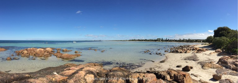
The main town in the region is Dunsborough which provides an ideal location to stay and explore this region. The area has some superb beaches, stunning coastline walks as well as an excellent wine growing area with many great restaurants, offering a wonderful quiet holiday spot to relax for a few days or even longer.


Leeuwin-Naturaliste National Park has significant stands of karri and jarrah forest, as well as an extensive network of caves – some of which are accessible by the public. It also has the cave known as Devil’s Lair which has important archaeological significance.
The rugged coastline stretches 120 km from the northern end at Bunker Bay to Augusta at the southern end and has many features of interest including the granite formations, sugarloaf rock and canal rocks. The coastal area also contains many beaches with well-known surf breaks, such as Supertubes, Yallingup beach and Smiths Beach.


The vegetation found in the park varies from the coastal scrub-heath along the coastline that opens up into large areas of peppermint trees, banksia and karri forest.
A large variety of bird species inhabit the park including many sea birds, red-eared firetail, white-breasted robin, rock parrot and emu. Native mammals that can be found within the park include southern brown bandicoots, western grey kangaroos, western ringtail possums and brush wallabies.


The national park was created from crown lands along the Leeuwin – Naturaliste ridge at a time after the main primary industries in the region had been dairying and forestry, and when increased land use conflict was arising from the spread of wineries, increased population on hobby farms and other agricultural activities.
Since then many competing land uses have created a complex land management scenario for state and local government authorities trying to mediate quite conflicting issues. The national park is located on the some of the most vulnerable land in the region.
The ridge’s geology and the variations in vegetation are confined to a number of very narrow bands that follow the north–south orientation of the ridge.

On the rugged coast a few kilometres south of Cape Naturaliste in the Margaret River Region, a gigantic granite rock-island looms up out of the ocean. It is called “Sugarloaf Rock” because it looks like a sugarloaf, which supposedly has a conical/triangular shape like the rock. A footpath leads from the Sugarloaf Rock carpark to a viewing platform. From here you get superb views of Sugarloaf Rock and the cliffs and surf to the north and south.
Sugarloaf Rock is one of the region’s most spectacular coastal landforms and unique environments. It is no wonder that it is one of the hallmark images of Australian Landscape Photographer of the Year, Christian Fletcher and it has graced the cover of the Australian Geographic magazine.
It is a gigantic towering granite rock that emerges from the Indian Ocean extremely close to the mainland. The rock is situated within a designated nature reserve in the Leeuwin-Naturaliste National Park just off Cape Naturaliste near Dunsborough.
Its ocean side is battered by treacherous seas and the rock is separated from the coast by just a narrow channel of wild water. This has created a unique environment which is home much wildlife.
![[Group 0]-IMG_0068_IMG_0075-8 images](https://i0.wp.com/highlanderimagesphotography.com/wp-content/uploads/2016/02/group-0-img_0068_img_0075-8-images.jpg?resize=768%2C327&ssl=1)


This area has many wonderful walks with well marked trails, many of them along the rugged coastline giving some wonderful views over the ocean. One of the famous trails is known the Cape to Cape Walk Track and is a long-distance walk trail which meanders along the whole length of the Leeuwin-Naturaliste Ridge, which forms the backbone of the Leeuwin-Naturaliste National Park. Its start and finish are the lighthouses at the tips of Cape Naturaliste and Cape Leeuwin. The Track extends over 135 km of coastal scenery, sheltered forests and pristine beaches, and is in close proximity to the caves, vineyards and other features and attractions of the “South West Capes – Margaret River Region”.


Busselton is a small town to the north of Cape Naturaliste on Geographe Bay. Founded in 1832 by the Bussell family, Busselton has been one of the fastest growing regions in Australia in the last decade and has a population of approximately 20,000. Busselton is 220 kilometres (140 mi) south west of Perth, the capital of Western Australia. Busselton has been voted Western Australia’s top tourist town three times in 1995, 1996 and 2005

Busselton is home to the longest wooden jetty (pier) in the southern hemisphere stretching almost 2 km out to sea. Construction of the jetty began in 1853 and was continually extended until the 1960s when it reached its current length of 1841 metres. It was closed to shipping in 1972, and maintenance was discontinued for a time. Following major damage caused by cyclone Alby in 1978 and a fire in 1999 it was restored and improved. Since 2003 the jetty has offered visitors a tourist train ride, an underwater observatory and an interpretive centre.

Inland from Busselton is the Ambergate Nature Reserve and Trail Walk which is worth a visit to explore the inland bush land. Ambergate Reserve is a 75 hectare regional park which protects the remnants of scrubland and woodlands once common along the coastal plains of Busselton and surrounds. The reserve becomes ablaze with wildflowers in spring but also offers the visitor a chance to observe a variety of plants and wildlife throughout the year along its gentle, looping 4km walk trail.


South of Cape Naturaliste is the famous Margaret River region which is well know for the many wineries with 5,017 hectares under vine and 215 wineries as at 2012. Margaret River wine region is made up predominately of boutique size wine producers; although winery operations range from the smallest crushing 3.5 tonne per year to the largest around 7000 tonne. The climate of Margaret River is more strongly maritime-influenced than any other major Australian region. It has the lowest mean annual temperature range, of only 7.6C, and for good measure has the most marked Mediterranean climate in terms of rainfall, with only 200 millimetres of the annual 1160 millimetres falling between October and April. The low diurnal and seasonal temperature range means an unusually even accumulation of warmth. Overall the climate is similar to that of Bordeaux in a dry vintage. Although the region produces just three percent of total Australian grape production, it produces over 20 percent of Australia’s premium wine market. The principal grape varieties are fairly evenly split between red and white; Cabernet Sauvignon, Chardonnay, Sauvignon blanc, Sémillon, Shiraz, Merlot, Chenin blanc and Verdelho.


![[Group 1]-IMG_0099_IMG_0108-10 images](https://i0.wp.com/highlanderimagesphotography.com/wp-content/uploads/2016/02/group-1-img_0099_img_0108-10-images.jpg?resize=768%2C185&ssl=1)
Passionate Photographer …. Lost in Asia
Stuart Taylor of HighlanderImages Photography has been making images for over 25 years and can offer a diverse range of photo imaging services with a focus on Asia and a documentary/photojournalistic style. These services include planning and executing a photo shoot on location but importantly all the post-processing and image preparation needed for the specific finished media format required by the customer. Stuart’s experience and knowledge in all of these aspects makes HighlanderImages Photography a one-stop-shop for a comprehensive and professional image production service.
Stuart can be available for a variety individual assignments or projects and he specialises in areas such as photojournalism, commercial, architectural, real estate, industrial, interior design, corporate, urbex, adventure, wilderness and travel photography. Stuart can also offer some innovative and advanced techniques such as HDR (High Dynamic Range) and Panoramic Photography.
Final image products can be delivered as high resolution images, prints, books, multimedia slideshows, videos and DVDs. Images from this website can be purchased as prints in a variety of sizes and media, as gift items or as digital downloads.
E-Mail : staylor@highlanderimages.com
Website : http://www. highlanderimages.com